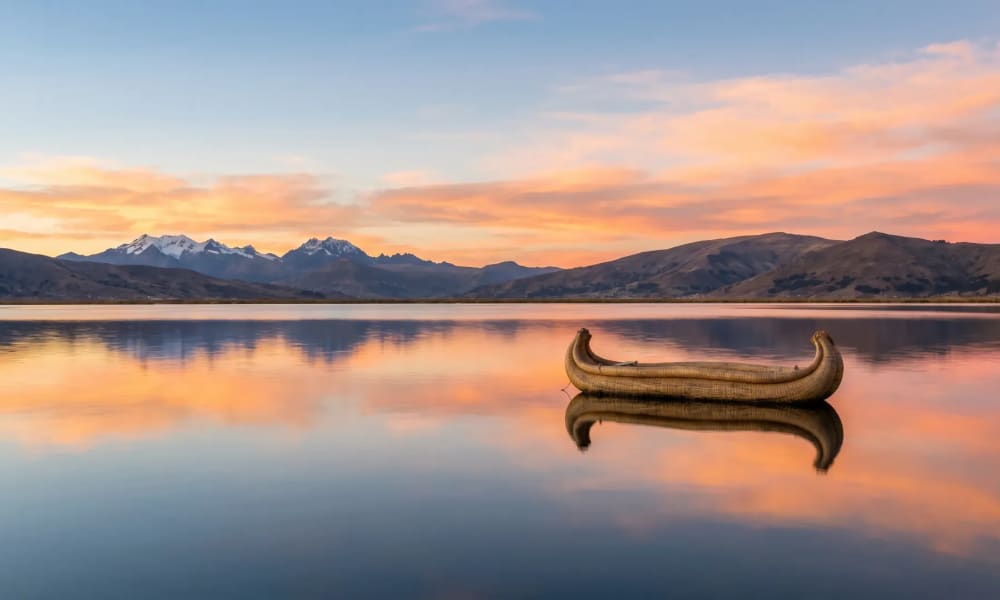
Lake Titicaca
Highest commercially navigable lake in the world — birthplace of the Inca Empire
Highest commercially navigable lake in the world — birthplace of the Inca Empire
At 3,812 meters, half in Peru and half in Bolivia, lies the lake from which, according to legend, Manco Cápac emerged to found the Inca Empire. Anyone who brings two or three days can experience floating reed islands, a UNESCO textile culture, and homestays with Quechua-speaking families — seamlessly connecting Peru with Bolivia.

Best travel time
May to September
Why Lake Titicaca?
Lake Titicaca is not a lake in the European sense. At 3,812 meters above sea level, with an area of 8,372 square kilometers and a maximum depth of 281 meters, it is the highest commercially navigable lake in the world — a formulation that is more precise than the common description of 'highest lake', as dozens of smaller mountain lakes lie significantly higher in the Andes. What makes Lake Titicaca unique is its combination: An inland body of water as large as Corsica, at an altitude where the air contains only two-thirds of the oxygen found at sea level, with regular passenger traffic between islands where people live in a culture older than the Inca Empire.
The lake is a border water: 60 percent belongs to Peru, 40 percent to Bolivia. And it is the birthplace of a civilization. According to legend, Manco Cápac, the first Inca ruler, along with his sister Mama Ocllo, emerged from the Titi-Qala rock on the Isla del Sol — an island on the Bolivian side of the lake. From there he traveled north to Cusco and founded the empire that later extended from Colombia to Chile. The myth does not say that he 'emerged from the lake', but from a specific sacred rock. This distinction is essential for Andean spirituality.
Anyone who still has time after visiting Cusco and Machu Picchu — and ideally travels onward to Bolivia — finds another facet of Peru at Lake Titicaca: less staged, starker, higher, and close to a daily life not made for visitors.
The Uros reed islands
About 30 boat minutes from Puno, in a protected bay, lies the most famous attraction of the lake: the floating islands of the Uros. About 120 artificial island surfaces woven from the root balls and stems of the totora reed, which grows here in shallow bays to a height of several meters. A few families live on each island, in reed huts, with reed boats at the shore — a cultural technique that has been documented for over 500 years.
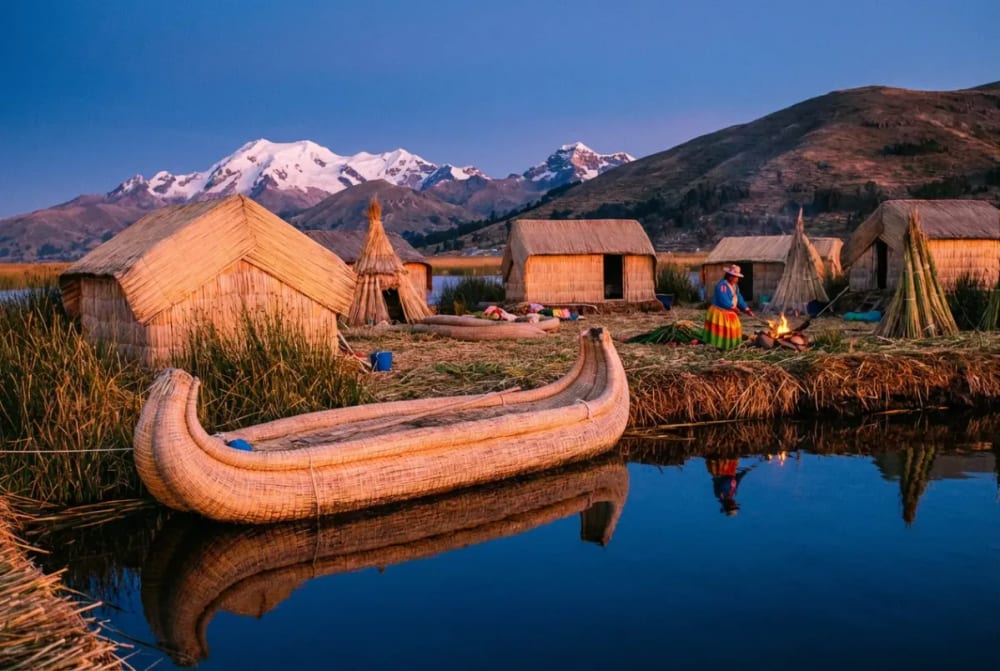
The origin story belongs to Andean mythology: The Uros are said to have originally retreated to the islands to avoid the Aymara and later the Incas. Today they are legally Peruvian citizens, but still speak Aymara among themselves. The islands need to be replenished with fresh reeds every two to three weeks, as the lower layers rot in the water. Once a year, an island is completely renewed.
Here comes the honest part that many travel providers omit: The touristically visited islands are no longer 'authentic' in the classical sense. An estimated 30 percent of the residents now commute from the mainland, many of the handicrafts offered are produced in Puno and only sold on the islands. The daily wave of visitors from two dozen boats has inevitably reshaped everyday life. This does not make the visit any less interesting — but it is not an unchanged window into the 15th century, but a vibrant community that has found a way to live from its history.
Insider tip Uros-Titino: If you want to experience Uros culture off the beaten path, do not leave from Puno, but from the Capachica Peninsula. The community Uros-Titino receives significantly fewer visitors, the families there generally live year-round on their islands, and the route can be combined with an overnight stay in Capachica. This is the insider tip that we regularly plan for travelers with time and interest in real encounters.
Taquile — Men knit, women weave
Two and a half boat hours east of Puno lies Taquile, an elongated island with around 2,200 inhabitants that at first glance appears like a Mediterranean isle — stone terraces, eucalyptus trees, small bays. At second glance, its uniqueness unfolds: Taquile is one of the few communities in the world where textile art still structures social life. The UNESCO included it in the representative list of the intangible cultural heritage of humanity in 2005 (formally entered in 2008) — not for a building, not for a festival, but for a craft practice.
The roles are clearly defined: Women weave the wide belts and cloths on looms that have hardly changed for generations. Men knit. The characteristic Chullos — the Andean hats with long ear flaps — are made exclusively by men, starting from elementary school age. Boys learn to knit before they can read; the craft is considered a prerequisite for marriageability.
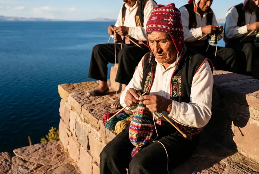
The Chullos are a readable code. A red-white Chullo signals: unmarried. A red-patterned Chullo with a dark top: married. The exact color combinations reveal age, status, and even mood — a folk craft that simultaneously serves as a social information system. The women wear elaborately embroidered blouses and black shawls that carry their own codes.
A visit to Taquile usually begins with the ascent from the port through terraced potato and quinoa fields to the main square at around 3,950 meters. There lies the cooperative Manos Diestras, where the certified textiles are sold — prices significantly above the Puno level, but with transparent origin. Most day trips combine Taquile with lunch in a local house. Anyone wishing to stay overnight will find simple homestays with families right at the main square.
Amantaní — Homestay with Quechua families
While Taquile is visited by excursion boats during the day, Amantaní is an hour further away — and is almost exclusively booked for two-day tours with overnight stay. That changes everything. When you arrive in Amantaní, you are not taken to a hotel, but assigned to a family that has been selected in rotation by the local tourism cooperative. The income is distributed evenly — a model considered one of the most successful examples of community-based tourism in South America.
Prices start at around 50 US dollars per person for two days including boat, accommodation, three meals, and a local guide — unbeatable value, but no substitute for comfort. The rooms are simple, the sanitary facilities rustic, and hot water is not guaranteed. What you get is uniquely different: a dinner of quinoa soup, Muña-tea, and potatoes from the own field, a family that speaks Quechua and teaches you the basic vocabulary, and at night a starry sky in a darkness that has been lost in Europe for decades.
In the afternoon, the community collectively ascends the two sacred peaks of the island: Pachatata (Father Earth) and Pachamama (Mother Earth), both at around 4,135 meters — that is 320 meters above sea level. On both peaks stand pre-Inca temple complexes that are still actively used by the residents during the summer and winter solstices. The sunset from Pachatata over the lake, with the Bolivian shore on the horizon, is one of those silent moments that leave a mark.
In the evenings, traditional clothing is worn for dancing — families lend guests the embroidered Polleras (women's skirts) and ponchos, and the village meets in the community hall. This sounds folkloric in description; in reality, it is more like a local village evening where visitors are allowed to participate. Those who embrace it experience Lake Titicaca not as a sightseeing spot, but as a place.
Peruvian or Bolivian side?
The lake is divided — and the two sides feel distinctly different. The Peruvian side with Puno is more accessible, better developed, and more touristy. Here lie the Uros Islands, Taquile, and Amantaní; here the trains and buses from Cusco arrive.
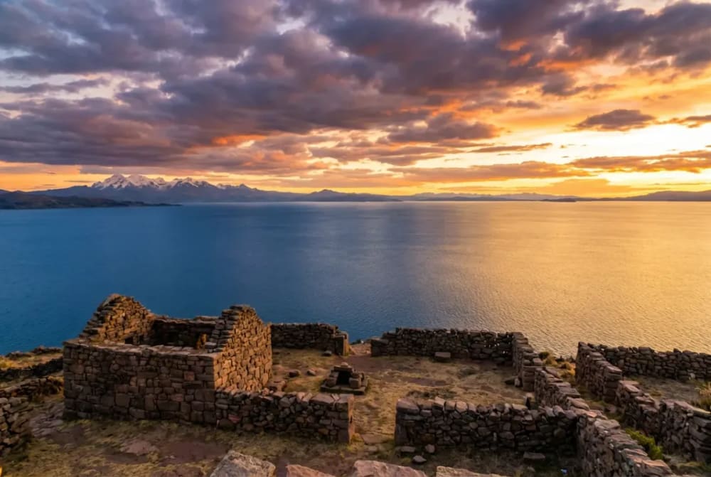
The Bolivian side around Copacabana is quieter, more provincial, spiritually charged. The small town on the bay is a pilgrimage site — the Basilica of the Virgin of Copacabana has attracted pilgrims from all over the Andes since the 16th century. From here, boats start to the Isla del Sol, where Manco Cápac emerged from the Titi-Qala rock and where the remains of an Inca temple are preserved. Anyone planning to stay two nights in Copacabana can hike extensively on the island — there are no cars, only donkey paths.
For travelers to Peru with a connection to Bolivia, we recommend a combination: Puno as a base for Uros and Taquile, then crossing the border and at least one overnight stay in Copacabana with an Isla del Sol excursion. The landscape on the Bolivian side is harsher, the villages smaller, the infrastructure simpler — those who experience the lake in both countries see two different facets of the same body of water.
Not to be confused: The Copacabana Peninsula in Brazil (the beach in Rio) has nothing to do with the Bolivian pilgrimage site — the name migrated to Rio with a statue of Mary in the 17th century.
Altitude and acclimatization — 3,812 meters
Puno is at 3,812 meters. Cusco is at 3,400 meters. Those coming from Cusco have done the most important acclimatization work — but they still ascend another 400 meters. This can cause sleep disturbances on the first night, and headaches for sensitive travelers. Those flying directly from Lima (sea level) should never choose Puno as the first high-altitude stop — the acclimatization order is always: Cusco/Sacred Valley first, Lake Titicaca thereafter.
A special role is played by the La Raya Pass at 4,335 meters — the watershed between the Atlantic and Pacific, which crosses the bus route from Cusco to Puno. The pass is over 500 meters higher than Puno itself. This is not a cause for concern, but rather an advantage: Those who get out at the pass for 20 minutes during the trip train their bodies for the coming days at the lake. The Inca Express plans an official photo stop.
At the lake itself, the same rules apply as in Cusco: plenty of water (three liters per day), no alcohol in the first 24 hours, avoid heavy meals. The local families in Amantaní traditionally serve Muña-Tea (Andean Mint) — unlike coca tea, the effects of this tea have been noted positively by many travelers with mild altitude sickness, even in the absence of clinical studies.
A curiosity on the side: In Lake Titicaca lives the Titicaca giant frog (Telmatobius culeus), an endemic amphibian threatened with extinction, which has adapted its loose skin folds to the low oxygen content in the water. It is rarely seen — it lives in deeper waters — but the biologists studying it indicate how unusual this ecosystem is.
Access from Cusco and onwards to Bolivia
Between Cusco and Puno, there are three routes — and the choice depends on time and budget.
The bus is the most popular option. The Inca Express from Cusco is less of a bus connection than a rolling day trip: Departure in the morning at 7 AM, arrival in the evening around 5 PM, about 66 US dollars including lunch and four guided stops. The route passes through Andahuaylillas (Sistine Chapel of the Andes), Raqchi (Temple of Viracocha), the La Raya Pass and Pukará (pre-Inca stone sculptures). Since July 2025, the fleet has been equipped with Starlink Wi-Fi — now surprisingly well available along the entire route. Travelers who want to cover daily stages between cultural destinations save a separate sightseeing day using the Inca Express.
The train from PeruRail — the Titicaca Train — runs three times a week and is an experience of its own: ten and a half hours of travel, panoramic carriages with open platforms, four-course lunch, live music on board. Starting at around 290 US dollars. For travelers with time and budget, it’s one of the most beautiful day trips in South America.
The flight is the fastest option. The nearest airport is Juliaca (JUL), about 45 minutes north of Puno. LATAM and Sky Airline fly several times daily from Lima (about 1.5 hours, 80-150 USD) as well as from Cusco. Upon arrival in Juliaca, proceed directly to Puno — the town itself has little to offer tourists.
For onward travel to Bolivia there are two border crossings: Yunguyo/Kasani is the recommended route to Copacabana (shorter, more scenic, less traffic), Desaguadero is the direct route to La Paz (longer, busier, often with waiting times). Bolivia Hop and Peru Hop operate both routes with English-speaking guides. German citizens do not need a visa for Bolivia, but a passport with six months of remaining validity and a return ticket.
Sillustani and Puno — worthwhile additions
About 34 kilometers northwest of Puno lies Sillustani — a peninsula in Lake Umayo with the most impressive Chullpas of Peru. These cylindrical burial towers made of hewn stone, some over twelve meters high, were built by the Kolla culture (before 1200 AD) and later reused by the Incas. The masonry technique already shows the precision that later characterized Sacsayhuamán. A half-day trip from Puno, often combinable with a visit to a traditional Andean house with guinea pig breeding.
Puno itself is unimpressive as a city — a harbor and trading town that exists because of the lake. However, those who arrive in February experience one of the continent's largest religious festivals: the Fiesta de la Candelaria, since 2014 a UNESCO World Heritage Site, with thousands of costumed dancers parading through the city for 16 days. The festival combines Catholic veneration of Mary with pre-Columbian fertility rites — to be experienced in this intensity only here. Hotels are booked months in advance.
Best travel time
The dry season from May to September is the most reliable period — clear visibility, hardly any rain, the lake trips proceed calmly. During the day, temperatures in Puno rise to 16 to 18 degrees, and at night they regularly fall below freezing point. The air is thin, dry, and cool. Warm clothing, gloves, and hats are a must from May, even if hiking in a T-shirt during the day.
The rainy season from December to March brings afternoon thunderstorms, lush green on the islands, and significantly emptier boats — except during the Candelaria week in February when Puno is in a state of emergency. The shoulder season April and October often offers the best conditions: clear visibility, moderate prices, and little tourist congestion on Taquile and Amantaní.
Planning your trip to Lake Titicaca individually
Lake Titicaca is not a destination you can 'quickly do.' It requires acclimatization, an honest expectation of the Uros, and ideally, the willingness to exchange hotel comfort for genuine encounters on Amantaní for a night. Those who embrace this get one of the most impressive stops in Peru — and the most natural transition to Bolivia.
We plan your route with the right sequence (Cusco before Puno, not vice versa), the right means of transportation (Inca Express, Titicaca Train or flight via Juliaca) and carefully selected partners on site — from the Uros-Titino community on Capachica to experienced homestay families on Amantaní. Including border crossing and connections in Copacabana if Bolivia is part of your trip.
Two routes are particularly recommended:
- Peru & Bolivia: Lake Titicaca and Uyuni Salt Flat — the great Andean route across both countries
- Peru intensive: Inca, Amazon and Rainbow Mountain — Lake Titicaca as part of an in-depth Peru tour
For a personal conversation and a customized offer, contact our Peru team — we usually respond within 24 hours.
To book a trip or for more information, contact us. We'll help you plan and guide you through your upcoming adventure!
Frequently Asked Questions
Two full days are the minimum: one day for Uros and Taquile as a day trip from Puno, a second day with an overnight stay on Amantaní. Three days are better — then there is time for Sillustani and, if you are traveling towards Bolivia, a relaxed border crossing with an overnight stay in Copacabana. Less than two days hardly justifies the long journey.
Both. The islands commonly visited from Puno are heavily geared towards visitors — about 30 percent of the residents now commute from the mainland, and many handicrafts come from Puno. That doesn’t mean there is no real culture — it means the families have found a way to live off their history. Those seeking a less touristy access go from the peninsula **Capachica** to the community **Uros-Titino**: significantly fewer visitors, families live there mostly year-round on the islands.
A simple room with a Quechua-speaking family, three homemade meals, no guaranteed hot water, and toilets mostly outside the main building. In the afternoon, a joint hike to Pachatata (4,135 m) with sunset, and in the evening a dance evening in traditional attire. Prices start at around **50 US dollars per person** for two days including boat, accommodation, and meals. Those expecting hotel comfort will be disappointed. However, those seeking one of the most authentic community tourism experiences in South America will be pleased.
If you only have time for one side: the **Peruvian** (Puno). Here lie the main islands and the best infrastructure. Those who continue to Bolivia should connect **both sides**: Uros and Amantaní from Puno, then a border crossing to **Copacabana** with an Isla-del-Sol excursion. The Bolivian side is quieter, more spiritual, with the founding myth of the Inca Empire at the Titi-Qala rock.
By bus in about three to four hours across the border crossing **Yunguyo/Kasani** — the more scenic and recommended route. **Bolivia Hop** and **Peru Hop** operate daily with English-speaking guides and take care of border formalities. German citizens do not need a visa for Bolivia, but must have a passport with six months of remaining validity. The alternative border crossing **Desaguadero** leads more directly to La Paz — busier, often with waiting times, and not the first choice for a pure Copacabana stay.
Yes — as a logistics base. Puno itself has little charm, but it is the starting point for all lake trips, the arrival point for buses and trains from Cusco, and the natural overnight stop before an early start to Uros. One to two nights are sufficient. For travelers during the Candelaria week in February, the city is worthwhile as an independent destination — the UNESCO festival is one of the most intense Andean festivals overall.